Expansion of Standardized Electrofishing in the Peoria Reach
Boat-mounted pulsed-DC electrofishing in off channel and backwater habitats of the Peoria Reach of the Illinois River Waterway was conducted to pair with ongoing LTEF main-channel border and some side-channel habitats sampling to fulfill the knowledge gap of fish communities in these habitats and provide a more complete assessment of the Peoria Reach. Sampling occurred from 2019-2020 to cover the wide range of habitat types using Long-Term Resource Monitoring (LTRM) protocols. Fish data collected consisted of species identification, length, and weight. Water quality data measured at each site consisted of depth, dissolved oxygen, specific conductivity, velocity, Secchi transparency, and chlorophyll a. Additionally, the extension of electrofishing was to assess the native planktivores and fish communities in relation to the enhanced contracted commercial fishing efforts on bigheaded carp implemented by the Illinois Department of Natural Resources (IDNR) in the Peoria Reach.
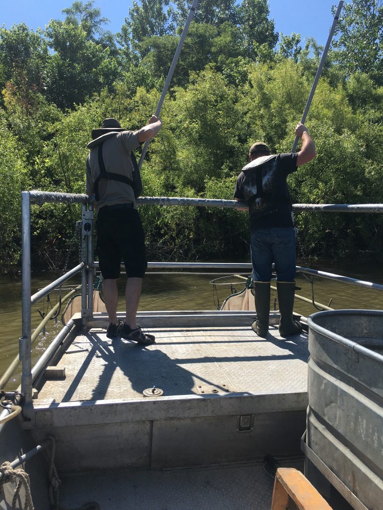
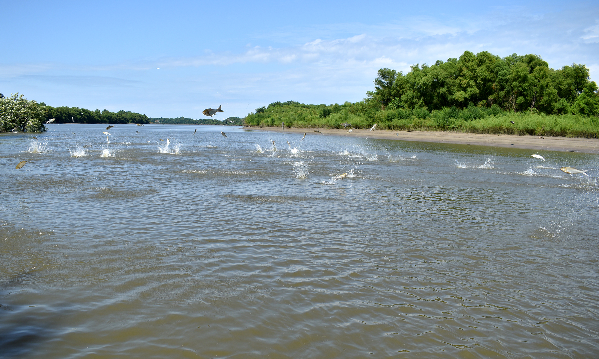
Monitoring zooplankton pre- and post-removal of invasive carp
Zooplankton are an essential part of any aquatic system as all fish species are dependent on them in at least one stage in their development, some species throughout their entire life cycle (for example, shad, paddlefish, bighead and silver carp). Of these species, silver and bighead carps have invaded and become established throughout much of the Mississippi River basin, including the Illinois River, and are now threatening the Great Lakes. Consequently, an effort to remove invasive carp through harvest has been undertaken by a number of collaborators including the Illinois Natural History Survey.
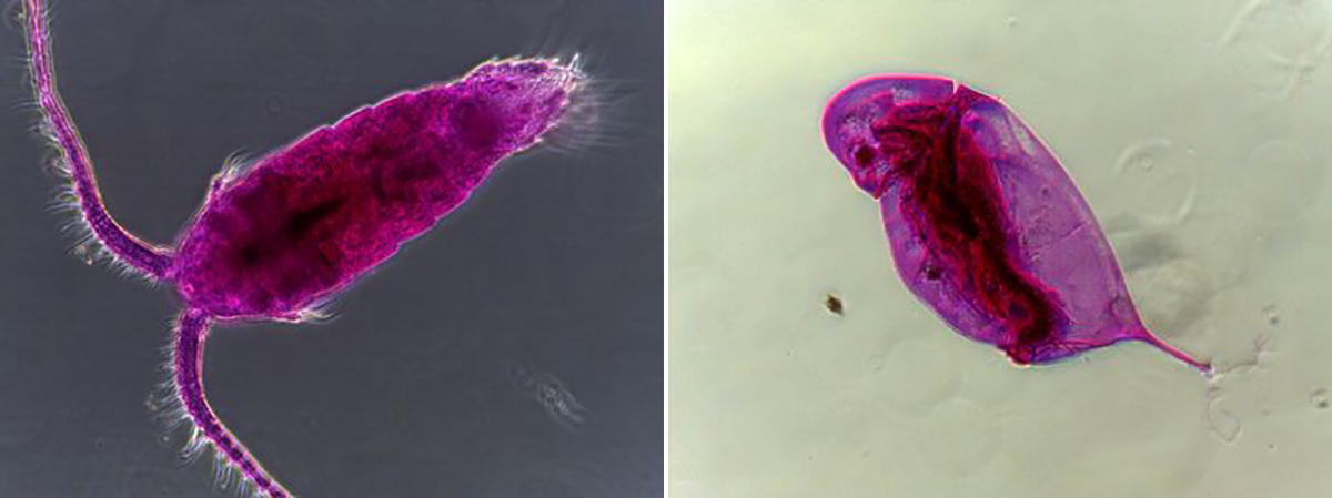
The IRBS component of this effort was to better understand ecosystem effects by monitoring zooplankton and water quality data in all six reaches of the Illinois River from Channahon to Grafton. This was done pre- and post-removal of invasive carp; these data were also compared to historic samples from pre-establishment (1993–2000) and post-establishment (2000–present) of invasive carp in the Illinois River.
Historic ecology of freshwater mussels in the Illinois River
The past century has been a period of major change for our aquatic systems. A few of the more notable events in the Illinois River include the opening of the Chicago Shipping and Sanitation Canal in 1900, the construction of navigational locks and dams in the 1930s, and the introduction of invasive zebra mussels and invasive carp. Trying to understand the impacts of these changes is a daunting task, but fortunately we have a silent sentinel who has been keeping watch. Mussel shells deposit annual growth lines, which are very similar to the growth rings produced by trees. Just as tree rings can be used to study fires and droughts, the annuli of mussel shells can teach us about changes during the animal’s lifetime. Through the combined use of museum specimens, modern-day animals, and 1,000-year-old archeological shell material, mussel shells can tell us a story that encompasses the past millennium. We processed the shells to create paper-thin cross sections, which were used to study the mussel’s age, growth rates, and any disturbances that happened during its lifetime. These same mussel shells and museum specimens were also used to study legacy contaminants and how their concentrations have changed over time, as well as stable isotopes signatures, which shed light on different nutrient sources.
Accuracy Assessment (AA) project: USGS, UMESC
The Upper Midwest Environmental Science Center (UMESC) maintains an extensive database of Land Cover/Land Use data of the Upper Mississippi River System (UMRS). Land Cover/Land Use data is obtained through photo interpretation of aerial photos (thematic mapping) and applying a General Wetland Vegetation (GWV) class to the landscape. The last complete Land Cover/Land Use data was collected in 2000, so a new effort began to update the dataset. Accuracy Assessment (AA) for the 2010 General Land Cover/Land Use Mapping Project was designed to test how well photo interpreters were able to assign GWV classes to the landscape of the UMRS. IRBS personnel were enlisted to assist the AA project on the La Grange Reach of the Illinois River Basin.
Model of Lake Michigan-Illinois River zebra mussel metapopulation: Illinois-Indiana SeaGrant
The zebra mussel has had profound impacts on the ecology of aquatic ecosystems in which it has invaded. Despite the evident problems caused by the zebra mussel, we lack ecosystem control strategies. This project evaluated a possible ecosystem control strategy for the zebra mussel. We hypothesized that the population structure of the zebra mussel itself may facilitate its control in certain instances. A system of local populations of sessile adults that depend on colonization by pelagic larvae were analyzed using metapopulation approaches. The zebra mussel in the connected waters of Lake Michigan and the Illinois River system represents such a metapopulation. We proposed inverting metapopulation approaches to conservation biology, and suggested that species may be controlled, rather than conserved, by changing the probability of colonization among populations.
Peoria habitat rehabilitation enhancement program—fish monitoring 1998: USGS, EMTC
Knowledge of how fish community structure responds to major habitat alteration is essential for planning of future projects. IRBS determined the effects of island and side channel construction on fish populations of Peoria Lake at the request of the Rock Island District, U.S. Army Corps of Engineers.
Lake Chautauqua habitat rehabilitation enhancement program—larval fish production: USGS
This project evaluated the larval fish production in and escapement from an area managed for moist soil plant production (at the request of the Rock Island District, U.S. Army Corps of Engineers). Management of some moist soil units might be modified to enhance production of larval fish without significantly reducing the quantity or quality of vegetation produced. This research increased our understanding of how factors such as temperature, water level regulation and fish access affect production of selected species of larval fishes.
Effects of dredge material placement on macroinvertebrate communities
At the request of the Rock Island District, U.S. Army Corps of Engineers, IRBS helped determine the effects of dredge spoil on invertebrate communities. These data are needed to properly plan, manage, and mitigate dredging operations used to maintain the navigation channel for commercial traffic while simultaneously protecting invertebrate communities.
Abundance and size distribution of zebra mussel veligers in the Mississippi River
Through extensive field sampling and laboratory analysis, IRBS determined zebra mussel veliger production in the Mississippi River at the request of the Wisconsin DNR. Assessment of veliger production will facilitate management of this invasive aquatic species.
Sediment resuspension and budget for Peoria Lake Land Management System: USGS, US Army COE
IRBS determined sediment resuspension and budget at the request of the Waterways Experiment Station by monitoring weather parameters (wind speed and direction) and turbidity at upper Peoria Lake. These data will be used to understand relationships between wind-generated waves, sediment resuspension, and turbidity.